Patchy, Gorgeous Sonora Pass

Leavitt Meadow, Sonora Pass (9/27/18) Dave Butler

9,000′, Sonora Pass (9/27/18) Dave Butler

8000′, Sonora Pass (9/27/18) Dave Butler
Sonora Pass (CA -08) is the second-highest pass in the Sierra Nevada (9,624′). Only Tioga Pass surpasses it.
Like the Tioga Road (CA-120E), fall color along the Sonora Pass is often removed from the highway, though there are places where it gets up close and personal.
Color spotter Dave Butler found it at elevations 8,000′, 9,000′ and at Leavitt Meadow Vista.
His images show green, lime, yellow and orange-red quaking aspen that are at the high end of being Patchy, with Near Peak color just around the bend. ![]()
Sonora Pass (9,624′) – Patchy (10-50%)
Exotic Fiesta in San Jose

Chinese pistache, San Jose (9/26/18) Anson Davalos
Bay Area color spotter Anson Davalos found a San Jose park draped with electric pink, yellow, orange and lime Chinese pistache, Pistacia chinensis, as if decorated for a fiesta.
The colorful trees are one of the first exotic varieties to show fall color, and carry long-lasting vibrance for weeks. Native to western and central China, it is now so common a non-native tree in California, that they are naturalizing. ![]()
San Jose (82′) – Just Starting (0-10%)
Quincy

Quincy (9/27/18) Shelley Hunter

Downtown Quincy (9/27/18) Shelley Hunter
Quincy is a town where its trees are as big as its people.
This Northern Sierra gold rush town (established as Elizabethtown in 1852) was soon bustling after a 28-ounce gold nugget was discovered. Several rich mining claims followed. The town (named after John Quincy Adams) grew to 2,500, before silver strikes at Virginia City, Nevada lured miners away.
Today, just 1,728 souls live there. The quiet country nature of Quincy is evident in Shelley Hunter’s snaps, in which towering trees shade lightly traveled streets and neighborhoods.
Fall color is now Patchy in Quincy with peak typically occurring in mid October. Of particular beauty, and it itself worth the trip to Quincy, are landmark sugar maples and sycamore that grow on the grounds of the Plumas County Courthouse. Another prized autumn photograph is Community United Methodist Church on Jackson St. when it is embraced in fall color. ![]()
Quincy (3,432′) – Patchy (10-50%)

Quincy (9/27/18) Shelley Hunter

Quincy (9/27/18) Shelley Hunter

Quincy (9/27/18) Shelley Hunter

Quincy (9/27/18) Shelley Hunter

County Courthouse, Quincy (9/27/18) Shelley Hunter
Sky High Over Mammoth

Rainbow Falls, Mammoth Lakes (9/25/18) Josh Wray

Agnew Lake, Mammoth Lakes (9/25/18) Josh Wray

Twin Lakes, Mammoth Lakes (9/25/18) Josh Wray

Mammoth Lakes Basin (9/25/18) Josh Wray
In a week, Mammoth Lakes has transitioned from Patchy to Peaking. And, Mammoth Lakes color spotter Josh Wray was sky high over it.
To see it all, he rode an exhilarating scenic flight with SkyTime Helicopter Tours out of the Mammoth Airport. Then, returned to earth to hike with a friend around lakes and along trails that are natural boulevards through bright yellow arbors of rustling aspen leaves.
Josh reports that fall color has matured quickly and though it will likely remain good for at least another week, we’re declaring Mammoth Lakes as a GO NOW! destination and the Rainbow Falls trail as this week’s Hike of the Week.
This is big country. Hikes can vary from heart thumping to easy romantic strolls. Josh recommends, “Head up to Lake George an hour after sunrise for the best light.” Or do as Josh did and get above it all on a helicopter tour. Anyway you experience Mammoth, it’s a 360-degree adventure. ![]()
Mammoth Lakes Basin (8,000′ and Up!) – Peak (75-100%) GO NOW!

Lake George, Mammoth Lakes (9/25/18) Josh Wray

Aspen, Mammoth Lakes (9/25/18) Josh Wray

Rainbow Falls, Mammoth Lakes (9/25/18) Josh Wray

Lake George, Mammoth Lakes (9/25/18) Josh Wray

Rainbow Falls, Mammoth Lakes (9/25/18) Josh Wray

Sugar Shack

M. Martis Creek Shack, Brockway Summit, Hwy 267 (9/27/18) Robert Kermen

M. Martis Creek Shack, Brockway Summit (9/27/18) Robert Kermen
Two shacks, one at Red Lake Creek in the Hope Valley (CA-88) and another at Middle Martis Creek near Brockway Summit (CA-267) compete for the title of the most photographed sugar shacks in California.
While they are not technically les cabane à sucre, what French Canadians call cabins used to boil sap into maple syrup, these California sugar shacks are, with their seasoned boards embraced by autumn’s beauty, architectural cousins.
Robert Kermen visited the Martis Creek shack today, saying the aspen grove surrounding it is Near Peak with remaining leaves a bold blend of green, lime, yellow, orange and red. He wrote, “Wish those walls would talk. Lots of photographers must have stopped here over the years.”

M. Martis Creek Shack, Brockway Summit (9/27/18) Robert Kermen
The last time I was there, I happened by on a weekend, and worked around portrait photographers who were there to shoot wedding photos of future brides. The ladies posed like magazine models leaning against the weathered boards and backed by a yellow blur of leaves.
On Monday, I hope to return and capture it before the last of the autumn’s memories have fluttered away. ![]()
Middle Martis Creek (7,000′) – Near Peak (50-75%) GO NOW!
Feather River Canyon Gold

Belden (9/26/18) Shelley Hunter

Belden (9/26/18) Shelley Hunter

Twain Store and RV Park, Twain (9/26/18) Shelley Hunter

Feather Bed Inn, Quincy (9/26/18) Shelley Hunter
The American River became world famous in 1848 after word spread of the discovery of gold at Coloma. However, it was just one of many rivers that drop out of the Sierra Nevada, Cascade and Klamath ranges where gold was found.
A strike by California pioneer John Bidwell on July 4, 1848 on a bar along the middle fork of the Feather River made him over $1 million richer (in today’s dollars), giving Bidwell another reason to celebrate on that Independence Day. News of his strike thereafter attracted thousands for “easy pickin’s” along the Feather, late into the 1800s.
Soon, miners were exploring the Feather River Canyon from Chico to Chester, often establishing short-lived towns along the way. Similar boom and bust stories happened over all of northern and eastern California.
Today, many of the gold rush towns the miners established remain as small resorts, remote mountain communities and surviving relics of the era.
Shelley Hunter, owner of the Quincy Feather Bed Inn – a peaceful retreat canopied by beauty in autumn, responded to a call we’d made asking for photographs of her area of Plumas County (Northern Sierra) with images of Just Starting bigleaf maple and black oak.
Feather River Canyon fall color is still two weeks away from Near Peak, though individual specimens and Indian Rhubarb along the upper banks of the Feather River are Near Peak.
She also sent views of Belden (CA-70), the Twain Store and RV Park with its collection of gold rush themed structures and the Feather River Canyon, whose gold discoveries brought thousands to this northern corner of the Sierra in the 1800s.

Feather River

Upper Fall River (9/27/18) Martha Fletcher

Indian Rhubarb, Trinity River (9/27/18) Julia Ellis
Along the Upper Fall River, Martha Fletcher found ornamental trees providing color at Spinner Fall Lodge, evidence that, even in the woods, exotic plants find our Mediterranean climate inviting.
Elsewhere in the Shasta Cascade, Indian Rhubarb, darmera, are turning orange red beside the Trinity River. ![]()
Quincy (3,432′) – Just Starting (0-10%)
Belden (2,221′) – Just Starting (0-10%)
Twain (2,858′) – Just Starting (0-10%)
Feather River Canyon – Just Starting (0-10%)
Fall River – Just Starting (0-10%)
More Orange Than Sunkist

Sagehen Summit (9/25/18) Jeff Simpson/Mono County Tourism
Mono County has listed four locations as must-see fall color destinations for the weekend: Lobdell Lake Road, Rock Creek Road, Virginia Lakes Road and Sagehen Summit, with more orange to be seen than at Sunkist Growers. (Click on photos to enlarge)

Aspen, Lobdell Lake Rd. (9/24/18) Jeff Simpson/Mono County Tourism

Virginia Lakes (9/20/18) Jeff Simpson/Mono County Tourism

Angler, Virginia Lakes (9/20/18) Jeff Simpson/Mono County Tourism

Virginia Lakes (9/20/18) Jeff Simpson/Mono County Tourism

Lobdell Lake Rd (9/24/18) Jeff Simpson/Mono County Tourism

Sagehen Summit (9/25/18) Jeff Simpson/Mono County Tourism

Sagehen Summit (9/25/18) Jeff Simpson/Mono County Tourism

Monitor Pass (9/21/18) Jeff Simpson/Mono County Tourism

Little Antelope Pack Station (9/24/18) Jeff Simpson/Mono County Tourism

Lobdell Lake Rd. (9/24/18) Jeff Simpson/Mono County Tourism

Lobdell Lake Rd. (9/24/18) Jeff Simpson/Mono County Tourism
Peak (75-100%) GO NOW! – “Sagehen Summit, in particular, has never been more brilliant as deep oranges and reds are currently covering the mountain from top to bottom.” Mono County’s Jeff Simpson urges, “head to this location first, as the colors won’t last much longer.
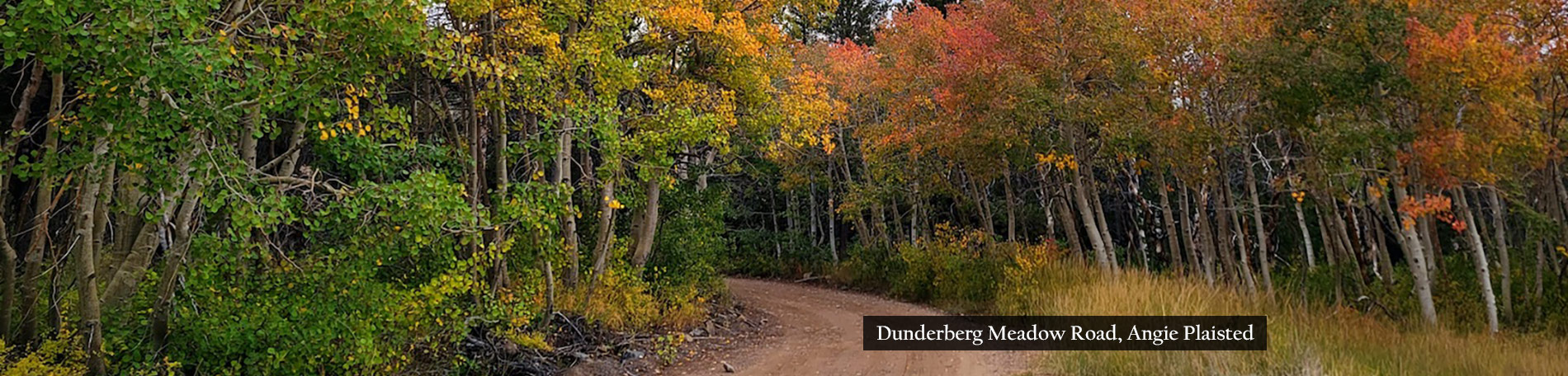
“Virginia Lakes Road and Rock Creek Road are at full peak along the upper sections of the roads. If you’re driving to Virginia Lakes, consider taking Dunderberg Meadows road to Green Creek for additional groves of quaking aspens. (AWD is recommended for this dirt road).
“Lobdell Lake Road is a lesser known destination off of Burcham Flat Road between Bridgeport and Walker.” Jeff says, “You’ll find full groves of oranges and reds near the top while yellows and greens are plentiful at the bottom. (AWD is recommended for this dirt road.)”
Near Peak (50-75%) GO NOW! – “Sonora Pass and Tioga Pass are both showing significant change in the upper elevations,” Simpson continues. “You’ll find peaking groves of aspens along the tops of the passes and at turnouts along the road. Some sections are still green the closer you get to US 395. Golden Gate Mine Road out of Walker/Coleville was absolutely brilliant earlier this week. Take this road to Little Antelope Pack Station at Rodriguez Flat for panorama views of yellows and oranges in the mountains above. (AWD is Recommended for this dirt road.) Book a pack trip or take a hike up Correl Valley Trailhead for additional viewing.” ![]()

Aspen, Lobdell Lake Rd. (9/24/18) Jeff Simpson/Mono County Tourism
Walker/Coleville/Topaz
- Monitor Pass (8,314′) – Patchy (10-50%)
- Lobdell Lake Road (8,600′) – Peak (75-100%) GO NOW! – Full peaking colors at the top with green/yellow leaves at the bottom. Colors should be great here for the next 10 days.
- Walker Canyon (5,200′) – Just Starting (0-10%)
- Towns of Walker & Coleville- Just Starting (0-10%)
- Sonora Pass (9,623′) – Near Peak to Peak (50-100%) GO NOW! – Still patchy in places but great near the top of the pass.
Bridgeport/Virginia Lakes
- Twin Lakes (7,000′) – Just Starting (0-10%)
- Virginia Lakes (9,819’) – Peak (75-100%) GO NOW! – Great color along the road and at lake level. Still green near the Conway Summit turnoff. Take Dunderberg Meadows Road to Green Creek Road for additional groves of color. (AWD is recommended)
- Conway Summit (8,143)- Just Starting (0-10%) – Still mostly green with a few yellow trees. A good 7-10 days away from a recommendation.
- Summers Meadow (7,200′)- Just Starting (0-10%) – Still mostly green along the road with some reds visible at the highest elevations.
Lee Vining
- Tioga Pass (9,943′) – Near Peak to Peak (50-100%) GO NOW! – Patchy in sections, especially at lower elevations. Saddlebag Lake Road should be your best bet.
- Lee Vining Canyon (6,781′) – Just Starting (0-10%)
- Lundy Lake & Canyon (7,858′) – Just Starting (0-10%)
Benton & 120 East
- Sagehen Summit (8,139’) –Peak (75-100%) GO NOW! -Unbelievable color there, right now. Go as soon as you can, as this will be the first location to go Past Peak. Then, you’ll be kicking yourself because YOU MISSED IT!
June Lake Loop
- June Lake Loop/Hwy 158 (7,654′) – Just Starting (0-10%)
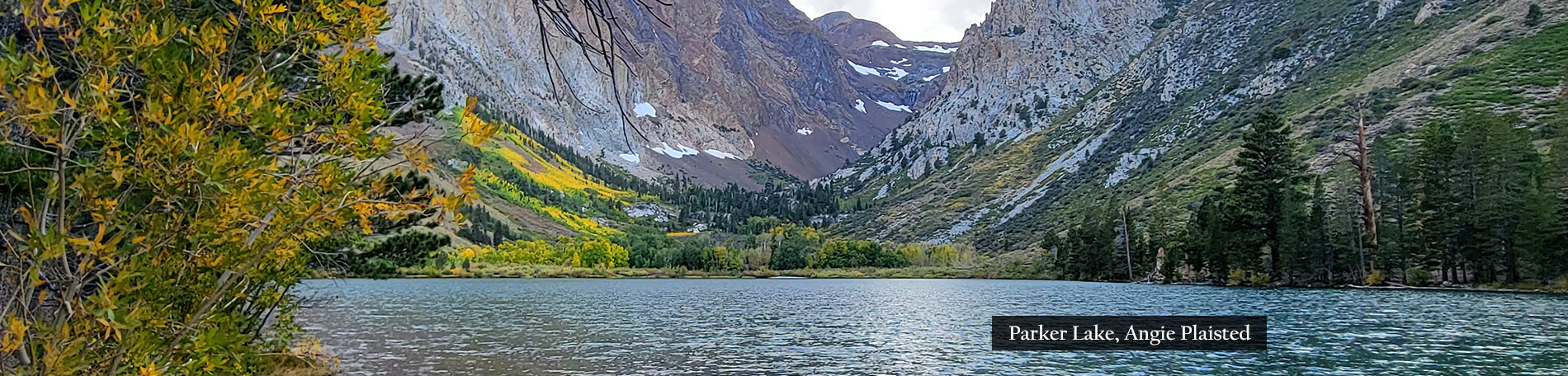
- Parker Lake (8,000′) – Just Starting (0-10%)
Mammoth Lakes
- Mammoth Lakes Basin (8,996′) – Patchy (10-50%) – There is significan color change occurring in the Lakes Basin. Laurel Canyon looks fantastic from US 395 if you want to make the hike or off-road drive (OHV required).
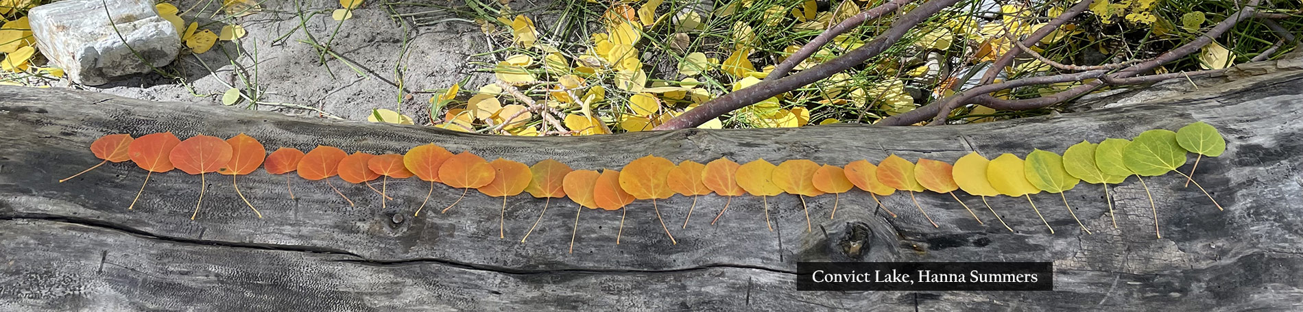
Crowley Lake/McGee Creek/Convict Lake
- McGee Creek Canyon (8,600’) – Patchy (10-50) – Colors look fantastic in the upper elevations from US 395. Green trees are still present near the road at US 395.
- Around Crowley community (6,781′) – Just Starting (0-10%)
- Convict Lake (7850′) – Just Starting (0-10%)
Rock Creek Canyon
- Rock Creek Road (9,600’) – Near Peak (50-75%) Go Now! -Full peak around the lake and down the road. Still green near US 395.

Head ’em up, Move ’em out

Groves Above Cardinal Village, M. Fork Bishop Creek (9/23/18) Matthew Pacheco
Time to hit the trail to Bishop Creek. GO NOW!
Reports filtering in from Bishop Creek Canyon (west of Bishop, CA) are confirming peak color at the highest elevations. The upper regions of the S. Fork and M. Fork are peaking. Only the North Fork of Bishop Creek (North Lake) has been lagging, and that could change any day within the coming week.
Here’s the long and the short of it. First, the long …

Parchers Resort, S. Fork Bishop Creek (9/23/18) Gigi de Jong
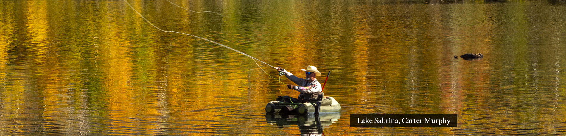
Bishop Creek Canyon – Peak (75-100%) at South Lake, Parchers and Lake Sabrina GO NOW!
Bishop color spotter Gigi de Jong has committed to submitting weekly reports from her color-rich area, this autumn. Her reports will be supplemented with observations from visiting and resident color spotters and photographers.
Gigi writes that on Sunday (9/23) Bishop Creek Canyon was “awash in yellow,” at its highest elevations, saying she caught the sun just setting with its “last rays catching the peaks and opposite ridge lines” as “aspen groves shined like polished lemons tumbling down the ravines,” with crisp and bright trees lining the road, “in counterpoint to the soft, reddish-orange tinge that illuminates bare peaks ahead.”

Lake Sabrina, M. Fork Bishop Creek (9/22/18) Alena Nicholas
She was treated to seeing “high wispy cirrus clouds,” the kind that “indicate the approach of wintery weather patterns” and that reflect pink, orange and lavender sunset light. Oh, to be there!
Lower Bishop Canyon remains green, but, Gigi continued, “further up the canyon, bright yellow is widespread. The forest of pines alongside the road appears to glow yellow from within – as if the forest floor is lit from beneath. At South Lake, gray granite rises up stark and craggy in contrast to the bright yellow that sparkles like sweet lemon drops offered by the gently waving branches.”

Willow Campground, S. Fork Bishop Creek (9/24/18) Gigi de Jong
Gigi found color to be “almost uniformly yellow with a few hints of orange and red. A branch overhanging the creek opposite Parchers Resort looks like it’s testing the water and has seared to a warm orange and crimson. A small patch of trees near Willow Campground are all deep orange and seem to stand in defiance against the surrounding green and slate gray of the rocky outcrop behind.”
“From Parchers Resort to South Lake the color is peaking at 75% – 100%, however it may deepen in color as the nights get cooler. Some leaves are showing signs of decay with brown spots scattered about, so the deeper fall colors may not materialize in abundance this year. A little lower down the canyon, from around Habeggers to near Parchers, the color is patchy at about 50%, and beautifully bright.”
Alena Nicholas agreed, reporting that “fall color is definitely ‘On The Way’, with color up in the higher elevations of Bishop Creek. Both the Sabrina Fork and South Fork of the creek has nice color, and both Sabrina Lake and South Lake too. As mentioned, North Lake is still pretty green.” (Click to enlarge photos)

Surveyor’s Meadow, S. Fork Bishop Creek (9/22/18) Alena Nicholas

South Lake, S. Fork Bishop Creek (9/22/18) Alena Nicholas

Weir Pond, S. Fork Bishop Creek (9/22/18) Alena Nicholas

S. Fork Bishop Creek (9/22/18) Alena Nicholas

Sabrina Approach, M. Fork Bishop Creek (9/22/18) Alena Nicholas

Sabrina Approach, M. Fork Bishop Creek (9/22/18) Alena Nicholas

S. Fork Bishop Creek (9/22/18) Alena Nicholas

Weir Pond, S. Fork Bishop Creek (9/22/18) Alena Nicholas

S. Fork Bishop Creek (9/22/18) Alena Nicholas

S. Fork Bishop Creek (9/22/18) Alena Nicholas

Surveyor’s Meadow, S. Fork, Bishop Creek (9/23/18) Matthew Pacheco

Approaching Parchers, S. Fork, Bishop Creek (9/23/18) Matthew Pacheco

Approaching Parchers, S. Fork, Bishop Creek (9/23/18) Matthew Pacheco

Approaching Parchers, S. Fork, Bishop Creek (9/23/18) Matthew Pacheco
Matthew “Mizzy” Pacheco, a CaliforniaFallColor.com reader for the past decade (yes, we’re in our tenth season) estimated Lake Sabrina would peak this week, but that “amazing color” would likely last a bit longer, as there was lots of green still to develop.
He also wrote that the ground cover at North Lake “was amazing … best I’ve seen it. But the main groves on the lake level are just starting. Mostly green,” including the large aspen grove seen on the way up. North Lake Road’s famous “leaf tunnel” is only 10 percent there, “though the trees near the 2nd parking pull of just before the tunnel looked amazing.” Beyond that, the groves appear green.
The Groves between Cardinal Village and North lake were beginning to look “kinda magic,” though Pacheco estimates they’ll need another week before darker yellows and oranges appear.

North Lake, Bishop Creek Canyon (9/24/18) Mark Harding
Color spotter Mark Harding did what few others have done in the past two weeks. He submitted pictures of North Lake. Others probably thought it was worthless to submit photos of North Lake, because it is Patchy. However, Mark’s photograph shows that the aspen gully stretching up 1,000′ from the lake is at Peak. When the Patchy aspen below it peak, they’ll do so quickly and a shot like Elliot McGucken captured (see our scrolling masthead) will be possible at sunset with high clouds.
Note: Tomorrow evening (9/27), at last report, the sky is predicted to be partly cloudy in the Eastern Sierra. Such forecasts are seen in the weather bar on the right of this page. Caution, they do change. Partly cloudy skies provide ideal conditions for sunset photography. Sunset will be at 6:53 p.m. Presently, days are hovering in the 70s with nights in the 30s with colder nights approaching, providing a perfect setup for spectacular color within the next two weeks up Bishop Creek Canyon. Right now, you cannot go wrong heading there and it will be even better next week.

N. Fork, Bishop Creek (9/24/18) Mark Harding

N. Fork, Bishop Creek (9/24/18) Mark Harding

Pine Creek Canyon (9/24/18) Gigi de Jong

Pine Creek Pack Station (9/24/18) Gigi de Jong
Pine Creek Canyon – Just Starting (0-10%)
Color here is provided mostly by “sunshine-yellow rabbitbrush that is in full bloom. The road (leading from the Round Valley north of Bishop) is lined with thick bushes of brilliant yellow flowers.” Gigi felt almost as if driving Pine Creek Canyon Midafternoon in Pine Creek Canyon is still warm and green. The sky is deep blue above the towering walls of the canyon. The sound of the burbling creek flowing below is quiet and soothing. A few cottonwood trees are showing their changing colors, but it the sunshine-yellow rabbitbrush that is in full fall bloom. The road is lined with thick bushes of brilliant yellow flowers. Driving up toward this head of this impressive glacial canyon makes one feel almost triumphant with a fall color guard lining the street.

Habeggers, S. Fork Bishop Creek Approaching Parchers, S. Fork, Bishop Creek (9/23/18) Gigi de Jong

Entrance to Pine Creek Canyon from Round Valley (9/24/18) Gigi de Jong
Lower Rock Creek Canyon – Just Starting (0-10%)
Lower Rock Creek Canyon (north of Bishop in the Round Valley) is still green, but fall color isn’t the reason to visit, right now. Mountain Biking is the reason. As, the Lower Rock Creek trail is the gold standard for mountain biking in the Eastern Sierra. It earns gold for its superior ride. And, once the color turns and also because fall is the golden season in this beautiful narrow canyon. If you go, pack a light camera for the up close and intense experience of sweeping through an arbor of leaves (best when they turn). A winding mountain road runs alongside this creek and trail, which also serves as an auto and motorcycle touring route. Stay tuned for updates on when the fall color is best here. ![]()
Now, the short …
South Fork, Bishop Creek
- South Lake (9,768′) – Peak (75-100%) GO NOW!
- Wier Pond (9,650′) – Peak (75-100%) GO NOW!
- Parcher’s Resort (9,260′) – Near Peak (50-75%) GO NOW!
- Willow Campground (9,000′) – Near Peak (50-75%) GO NOW!
- Surveyor’s Meadow (8,975′) – Near Peak (50-75%) GO NOW!
- Table Mountain Camp (8,900′) – Patchy (10-50%)
- Mist Falls and the Groves Above Bishop Creek Lodge (8,350′) – Patchy (10-50%)
- Aspendell (8,400′) – Just Starting (0-10%)
Middle Fork, Bishop Creek
- Lake Sabrina (9,150′)- Peak (75-100%) GO NOW!
- Sabrina Approach (9,100′) – Peak (75-100%) GO NOW!
- Sabrina Campground (9,000′) – Near Peak (50-75%) GO NOW!
- Groves Above Cardinal Village (8,550′) – Patchy (10-50%) – At the high end of Patchy, likely to peak within a week.
- Four Jeffries (8,000′) – Just Starting (0-10%)
- Intake II (8,000′) – Just Starting (0-10%)
- Big Trees Campground (7,800′) – Just Starting (0-10%)
North Fork, Bishop Creek
- North Lake (9,225′) – Patchy (10-50%)
- North Lake Rd (9,000′) – Just Starting (0-10%) – ground covers are the best in years, aspen groves still green

Groves Above Cardinal Village, M. Fork Bishop Creek (9/22/18) Alena Nicholas

Shine On Harvest Moon

Harvest Moon, Lassen Peak (9/23/18) Chico Hiking Association

Mountain Maples and Oceanspray (9/24/18) Chico Hiking Association

Mountain Maples (9/24/18) Chico Hiking Association

Indian Rhubarb, Deer Creek, CA-32 (9/24/18) Chico Hiking Association
On its explorations yesterday, the Chico Hiking Association captured the harvest moon (the full moon nearest the autumnal equinox) rising over Lassen National Park.
A harvest moon is called such, because it puts out a lot of bright light in early evening, that has traditionally aided farmers with bringing in the harvest, the Old Farmer’s Almanac tells us.
Harvest moons also have the shortest difference in the time that they rise each day. Whereas in other months of the year, moons rise about 50 minutes apart on each successive day. Near the autumnal equinox, a harvest moon rises both near sunset and 30 minutes later than the previous day.
That is a yearly minimum difference which explains why it can appear that there are multiple full moons in a row. If you happened to photograph this year’s harvest moons, send images to editor@californiafallcolor.com. We’d love to share them.
On its weekend explorations, CHA visited Elam Campground in Lassen National Forest (50 mi. east of Chico) where sunlight, not a harvest moon, illuminated the gold and orange foliage of Mountain Maple, Acer glabrum, and Oceanspray, Holodiscus discolor, formidable shrubs ( 5 to 20′ tall) that grow along rocky slopes.
Indian Rhubarb, Darmera, are approaching Near Peak beside CA-32 along Deer Creek.
Elsewhere in the Shasta Cascade Region, color spotter Jeff Titcomb sent the following snaps of a variety of native and exotic foliage exhibiting early peak color, including: California wild grape, firethorn (pyracantha), Pacific dogwood, bigleaf maple, and chokecherry. ![]()
Elam Campground (4,380′) – Near Peak (50-75%) GO NOW!

California Wild Grape , Quincy (9/22/18) Jeff Luke Titcomb

Firethorn, pyracantha, Quincy (9/22/18) Jeff Luke Titcomb

Pacific dogwood, Quincy (9/22/18) Jeff Luke Titcomb

Bigleaf Maple. Greenville (9/22/18) Jeff Luke Titcomb

Bigleaf maple, Greenville (9/22/18) Jeff Luke Titcomb

Chokecherry, Greenville (9/22/18) Jeff Luke Titcomb

Chokecherry (9/22/18) Jeff Luke Titcomb
8000 – 9000′ Patchy & Glorious

Lee Vining Canyon (9/23/18) Rodney Chai

Mt. Whitney Trail, near Whitney Portal (9/23/18) Rodney Chai
Near 9,000′ in the Sierra Nevada, you touch glory.