California Wild Grape

California Wild Grape, Cameron Park (10/5/18) John Poimiroo

California Wild Grape, Cameron Park (10/5/18) John Poimiroo

Fremont Cottonwood and California Wild Grape, Cameron Park (10/5/18) John Poimiroo

California Wild Grape, Cameron Park (10/5/18) John Poimiroo
California Wild Grape (Vitis californica) is a treat for fall color foragers.
It’s known to climb as high as 50′ and one specimen I found in Cameron Park easily topped that height. It had overgrown a stand of Frémont cottonwoods, with grapes hanging in bunches like Christmas ornaments all the way to the top of the trees.
This woody vine is found growing between sea level and 4,000′, often climbing into trees, Falcon Press’ Plants of Northern California reports.
In autumn, their large grape leaves turn a vibrant yellow or deep red at peak.
Only a few leaves had yet blushed, though I plan to return to get more pictures and purloin a basket of grapes, which have a very pleasant, mild and sweet grape flavor. ![]()
California Wild Grape (1,198′) – Patchy (10-50%)
Never Better – Sonora Pass

Sonora Pass (10/4/18) Jeff Simpson/Mono County Tourism

Sonora Pass (10/4/18) Jeff Simpson/Mono County Tourism

Sonora Pass (10/4/18) Jeff Simpson/Mono County Tourism

Leavitt Meadow, Sonora Pass (10/4/18) Jeff Simpson/Mono County Tourism

Leavitt Meadow Pack Station, Sonora Pass (10/4/18) Jeff Simpson/Mono County Tourism
Sonora Pass (CA-108) has never been better, Jeff Simpson of Mono County Tourism tells us.
He drove the route yesterday to find glorious orange and yellow quaking aspen and golden cottonwood along the way.
Leavitt Meadow is awash with warm-toned grasses and ringed with full peak aspen.
Once over Sonora Pass, it’s a short drive to refreshment in the high plains ranch town of Bridgeport (US 395) , not far from Bodie State Historic Park (CA 270), or continue on US 395 to Conway Summit and a search for nearby peak color along Virginia Lakes, Dunderberg, Summers Meadow and Green Creek Roads. ![]()
Sonora Pass (9,623′) – Peak (75-100%) GO NOW!

Gold Found at Frenchman Lake

Frenchmans Creek, Plumas County (10/3/18) Shelley Hunter

Frenchman Creek, Plumas County (10/3/18) Colin Birdseye

Frenchman Lake, Plumas County (10/3/18) Shelley Hunter

Frenchmans Creek, Plumas County (10/3/18) Shelley Hunter

Road to Frenchman Lake, Plumas County (10/3/18) Shelley Hunter

Frenchman Lake, Plumas County (10/3/18) Shelley Hunter

Frenchman Lake, Plumas County (10/3/18) Shelley Hunter
Frenchman Claude Francois Seltier came to Sierra Valley (southeastern Plumas County) in 1858 to search for gold.
It’s now being found along Frenchman’s Creek and on the road to Frenchman Lake where riparian grasses, aspen and cottonwood are gilding the landscape.
With a shoreline of 21 miles and a surface area if 1,580 acres, Frenchman Lake is a favorite water for fishing and camping. In winter the lake freezes and ice fishing occurs there. ![]()
Frenchman Lake (5,588′) – Patchy (10-50%)

Bishop Creek’s Over The Top

North Lake, Bishop Creek Canyon (10/1/18) Adam Potts
This has been a mind-boggling past week up Bishop Creek Canyon. You might say, “it was over the top!”
North Lake finally caught up with Lake Sabrina and South Lake, rushing from Patchy to Peak in a few days. Then, clouds, rain, snow, refreshing clear autumn air and rainbows filled the skies over Inyo County.

North Lake, Bishop Creek Canyon (9/30/18) Douglas Van Kirk
All that action attracted so many photographers that local color spotter Gigi de Jong described them as leapfrogging over one another for “the sweet spot and that great shot.””
What they saw, she described, were “soft clouds” sweeping across the sky “as the cumulus built in the late afternoon heat, then dissipated as the cool winds scattered them about.
“As the shadows played over the landscape, the colors seem to change from within. Sunlight brightened the yellows and shade deepened the oranges and reds.

North Lake Bishop Creek Canyon (10/1/18) Tracy Zhou
Every vista had something magical about it,” Gigi said, causing observers to see things they hadn’t noticed before, like an old log cabin opposite Weir Pond and lovers as in love with the scene as they were with each other.
So many images arrived, that it’ll take days to post a representative selection, here. We’ll do our best, but there are many repeats and we like to show variety. In the meantime, we’re over the top over what we received.
As for the outlook, color has almost peaked at the highest elevations, but there’s still great color to be seen up Bishop Creek Canyon for another two weeks. Presently, the color is peaking under 9,000′, and the storm just made it better. ![]()

Autumn Storm, US 395, Independence (10/3/18) Ursula Esser
South Fork, Bishop Creek
- South Lake (9,768′) – Peak to Past Peak (75-100%) GO NOW or YOU ALMOST MISSED IT!
- Wier Pond (9,650′) – Peak to Past Peak (75-100%) GO NOW or YOU ALMOST MISSED IT!
- Parcher’s Resort (9,260′) – Peak to Past Peak (75-100%) GO NOW or YOU ALMOST MISSED IT!
- Willow Campground (9,000′) – Peak (75-100%) GO NOW!
- Surveyor’s Meadow (8,975′) – Near Peak (50-75%) GO NOW!
- Table Mountain Camp (8,900′) – Patchy (10-50%)
- Mist Falls and the Groves Above Bishop Creek Lodge (8,350′) – Patchy (10-50%)
- Mountain Glen Campground (8,200′) – Patchy (10-50%)
- Four Jeffreys (8,000′) – Patchy (10-50%)
- Big Trees Campground (7,800′) – Just Starting (0-10%)
Middle Fork, Bishop Creek
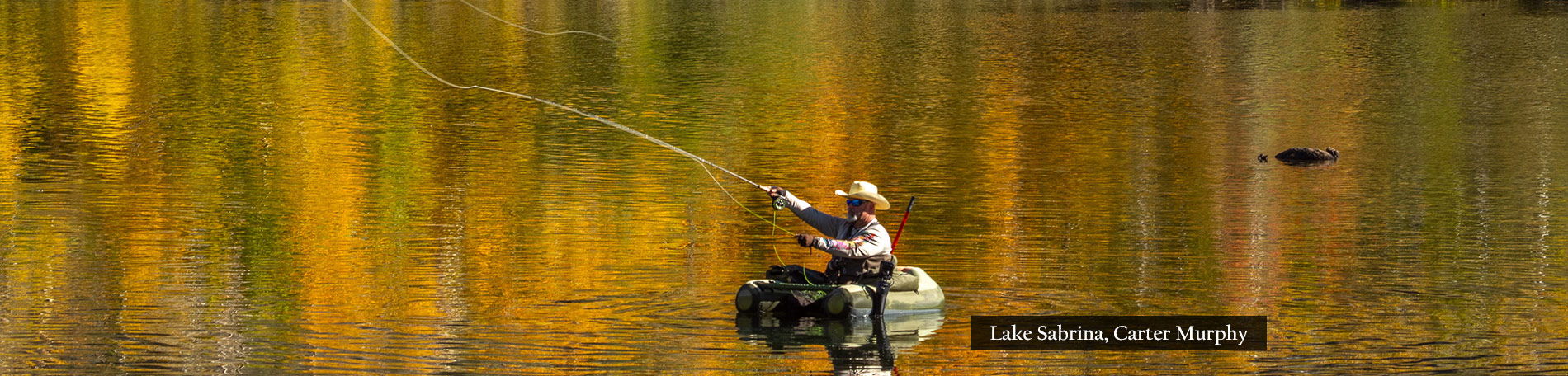
- Lake Sabrina (9,150′)- Peak (75-100%) GO NOW!
- Sabrina Approach (9,100′) – Peak (75-100%) GO NOW!
- Sabrina Campground (9,000′) – Near Peak (50-75%) GO NOW!
- Groves Above Cardinal Village (8,550′)- Near Peak (50-75%) GO NOW!
- Aspendell (8,400′) — Near Peak (50-75%) GO NOW!
- Intake II (8,000′) – Near Peak (50-75%) GO NOW!
- Bishop Park Group Campground (8,400′) – Patchy (10-50%)
North Fork, Bishop Creek
- North Lake (9,225′) – Peak (75-100%) GO NOW!
- North Lake Rd (9,000′) – Peak (75-100%) GO NOW!

Cardinal Village, Bishop Creek Canyon (10/1/18) Gigi de Jong

Log Cabin, Weir Pond, Bishop Creek Canyon (10/1/18) Gigi de Jong

Cardinal Village, Bishop Creek Canyon (10/1/18) Gigi de Jong

Bishop Park Group Campground, Bishop Creek Canyon (10/1/18) Gigi de Jong

Lake Sabrina, Bishop Creek Canyon (10/1/18) Gigi de Jong

North Lake Rd., Bishop Creek Canyon (10/1/18) Gigi de Jong

Mountain Glen Campground, Bishop Creek Canyon (10/1/18) Gigi de Jong

Grass Lake, Bishop Creek Canyon (10/1/18) Tracy Zhou

Grass Lake, Bishop Creek Canyon (10/1/18) Tracy Zhou

North Lake, Bishop Creek Canyon (10/1/18) Tracy Zhou

North Lake, Bishop Creek Canyon (10/1/18) Tracy Zhou

Sabrina Approach, Bishop Creek Canyon (10/1/18) Gigi de Jong

North Lake, Bishop Creek Canyon (9/30/18) Daniel Danzig

North Lake, Bishop Creek Canyon (9/30/18) Daniel Danzig

North Lake, Bishop Creek Canyon (9/30/18) Daniel Danzig

S. Lake Rd., Bishop Creek Canyon (10/1/18) Adam Potts

North Lake, Bishop Creek Canyon (9/29/18) Douglas Van Kirk

S. Lake Rd., Bishop Creek Canyon (10/1/18) Adam Potts

S. Fork Bishop Creek, Table Mountain Camp (10/1/18) Adam Potts

S. Lake Rd., Bishop Creek Canyon (10/1/18) Adam Potts

S. Lake Rd., Bishop Creek Canyon (10/1/18) Adam Potts

Last Call Above 9,000′

That 395 House (10/2/18) Liz Grans/Mono County Tourism
It’s last call above 9,000′ feet in Mono County, and what a way to close out fall color viewing at those elevations!
Snow dusted the mountain tops above 10,000′ today, though this didn’t damage fall color. In fact, it improved it, providing a spectacular backdrop for the color and rainbows.

Virginia Lakes (10/2/18) Jeff Simpson/Mono County Tourism

Virginia Lakes (10/2/18) Jeff Simpson/Mono County Tourism

Virginia Lakes (10/3/18) Liz Grans/Mono County Tourism

Virginia Lakes (10/3/18) Liz Grans/Mono County Tourism

Conway Summit (10/2/18) Jeff Simpson/Mono County Tourism

Conway Summit (10/2/18) Jeff Simpson/Mono County Tourism

Conway Summit (10/3/18) Liz Grans/Mono County Tourism

Silver Lake, June Lake Loop (10/2/18) Jeff Simpson/Mono County Tourism

McGee Creek (10/3/18) Josh Wray/Mammoth Lakes Tourism

Convict Lake (10/3/18) Josh Wray/Mammoth Lakes Tourism
Mono County is tracking exactly as it has in past years, so check this site for peak color previously and make your plans to see favorite areas, accordingly.
This is likely the last week to enjoy peak color at the Virginia Lakes, Upper Rock Creek, Lobdell Lake Road, Sagehen Summit, Sonora Pass and Tioga Pass. Jeff Simpson of Mono County Tourism reports. “All of these areas are at full peak and looking spectacular right now but will be rapidly approaching past peak as the week goes on.”
There are too many great trails peaking right now to name one as Hike of the Week. So, we’re suggesting this package of choices for inspirational hiking. Be advised, they climb to high elevations. So, be prepared with plenty of water, hiking sticks, a backpack holding extra layered clothing, sun screen, a hat, sunglasses and your camera or mobile device, of course.
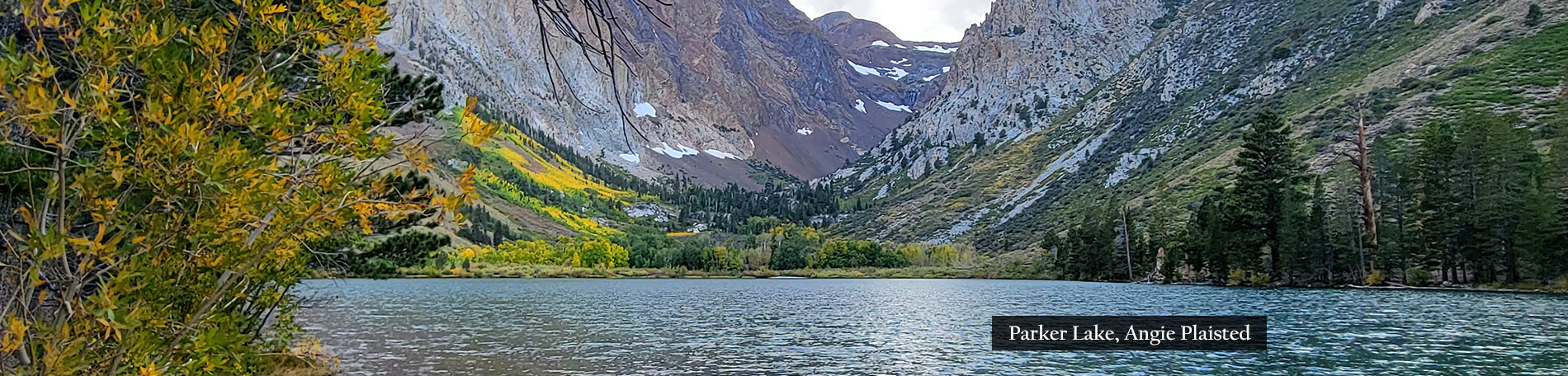
Now that you’re forewarned, be prepared for fair beauty along the Upper Rock Creek, McGee Canyon, Parker Lake, Lundy Canyon and Molybdenite trails with quaking aspen at higher elevations that will be perfect, this weekend.
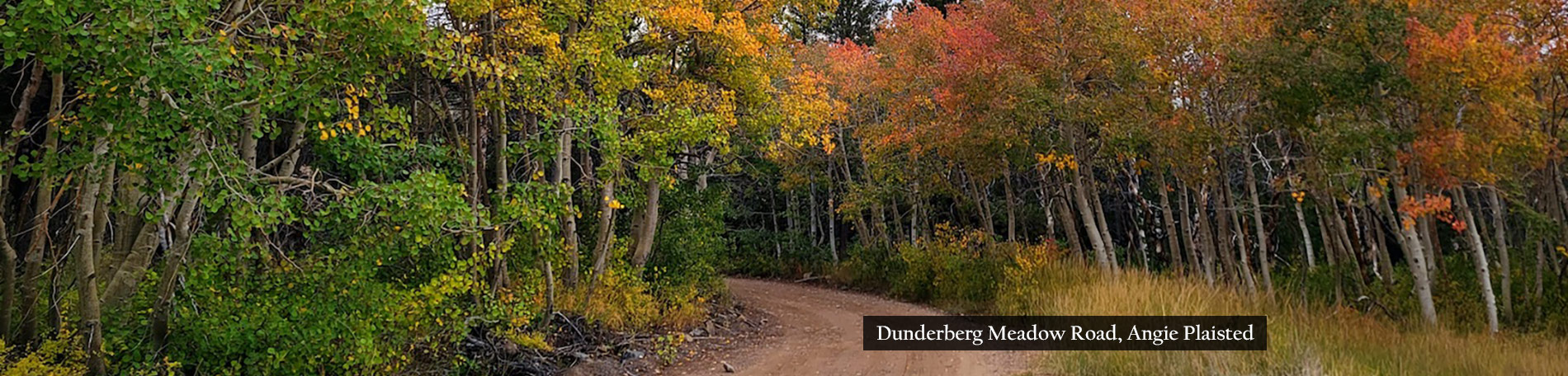
For a driving tour, start at Conway Summit (US 395) and drive up Virginia Lakes Road to Dunderberg Meadows Road, then to Green Creek and down through Summers Meadows road exiting back at US 395 on Green Creek Road. This loop has incredible color right now and you’ll be able to see five of Mono County’s premiere fall color destinations at once. AWD recommended.
East Bay color spotter, Darrell Sano was one of the photographers who headed to Mono County this past week in search of color. His route took him over Tioga Pass and through Yosemite National Park, before descending Lee Vining Canyon into Mono County, reporting “incredibly intense” rain during today’s storm and crawling at 30 mph in what appeared to be nightfall at 2 p.m.
Now you know why the National Park Service closes Tioga Pass once it snow accumulates. Fortunately it didn’t and CA-120E remains open to Mono County as peak color spreads across it. ![]()
Walker/Coleville/Topaz
- Monitor Pass (8,314′) – Near Peak (50-75%) GO NOW! – The pass is gilded with yellow and lime on the way up/down.
- Lobdell Lake Road (8,600′) – Peak (75-100%) GO NOW! – Fantastic color is hanging on, though this is likely the last Peak week for this elevation. AWD recommended.
- Walker Canyon (5,200′) – Just Starting (0-10%)
- Towns of Walker & Coleville- Just Starting (0-10%)
- Sonora Pass (9,623′) – Near Peak to Peak (50-100%) GO NOW! – Another week of strong color with Peak color over the pass and lime and yellow in Leavitt Meadow.
Bridgeport/Virginia Lakes
- Twin Lakes (7,000′) – Patchy (10-50%) – Will be Near Peak next week.
- Virginia Lakes (9,819’) – Peak (75-100%) GO NOW! – Wow. Virginia Lakes has had two solid weeks of peak color, but this is likely its last, as some stands are Past Peak near the lake, but still strong going up the road. AWD recommended.
- Conway Summit (8,143) – Patchy (10-50%) – We like Conway best when it’s a mix of green, lime, yellow and orange … like, right now. This broad area should hold for another two weeks of Near Peak and Peak color. Though technically Patchy, GO NOW!
- Summers Meadow (7,200′) – Patchy (10-50%) – Green along the road, but with emerging color yellow, orange and red higher up. In some years, Summers Meadow is one of the most beautiful areas of the Eastern Sierra. A definite must-see.
Lee Vining
- Tioga Pass (9,943′) – Peak (75-100%) GO NOW! – There’s lovely color near Tenaya Lake and spots of it through Tuolumne Meadows and over the pass. Saddlebag Lake Road is worth a sidetrip.
- Lee Vining Canyon (6,781′) – Patchy (10-50%)
- Lundy Lake & Canyon (7,858′) – Patchy (10-50%)
Benton & 120 East
- Sagehen Summit (8,139’) –Peak to Past Peak GO NOW as YOU ALMOST MISSED IT! – Still beautiful and worth the detour, but approaching Past Peak.
June Lake Loop
- June Lake Loop/Hwy 158 (7,654′) – Patchy (10-50%) – Still early.
- Parker Lake (8,000′) – – Patchy (10-50%) – Best bet.
Mammoth Lakes
- Mammoth Lakes Basin (8,996′) – Peak (75-100%) GO NOW! – Colors in the Mammoth Lakes Basin are still bright and vibrant. Definitely worth stopping by Lake George, then making your way back through Twin Lakes.
Crowley Lake/McGee Creek/Convict Lake
- McGee Creek Canyon (8,600’) – Patchy (10-50) – McGee is dragging its feet, but then it’s always been later than other canyons. Look for it moving to Near Peak next week and Peak the following week.
- Around Crowley community (6,781′) – Just Starting (0-10%)
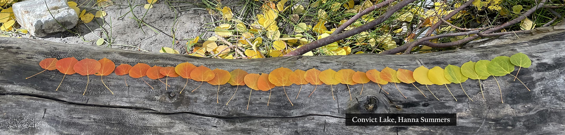
- Convict Lake (7850′)- Patchy (10-50) – Color is appearing around the lake, but it’s got another week before it truly gets electric.
Rock Creek Canyon
- Rock Creek Road (8,500’+) – Peak (75-100%) GO NOW! – With snow coating peaks above Rock Creek Lake, this is definitely the Peak of the Week above 8,500′.

Conway Summit (10/2/18) Jeff Simpson/Mono County Tourism

Rock Creek, Mono County (10/3/18) Josh Wray/Mammoth Lakes Tourism
Conway Summit (10/3/18) Liz Grans/Mono County Tourism

Carson Iceberg Wilderness (10/2/18) Jeff Simpson/Mono County Tourism

Virginia Lakes (10/2/18) Jeff Simpson/Mono County Tourism

Sonora Pass (10/2/18) Jeff Simpson/Mono County Tourism

Rock Creek, Mono County (10/3/18) Josh Wray/Mammoth Lakes Tourism

McGee Creek (10/3/18) Josh Wray/Mammoth Lakes Tourism

Rock Creek, Mono County (10/3/18) Josh Wray/Mammoth Lakes Tourism

Rock Creek, Mono County (10/3/18) Josh Wray/Mammoth Lakes Tourism
Carson Iceberg Wilderness (10/2/18) Jeff Simpson/Mono County Tourism

Siesta Lake, Yosemite National Park (10/3/18) Darrell Sano

Warren Fork, Lee Vining Canyon (10/3/18) Darrell Sano

Warren Fork, Lee Vining Canyon (10/3/18) Darrell Sano

Mono Lake Lookout, Lee Vining Canyon (10/3/18) Darrell Sano

Fire and Ice

Rock Creek, Mono County (10/3/18) Josh Wray/Mammoth Lakes Tourism

Rock Creek, Mono County (10/3/18) Josh Wray/Mammoth Lakes Tourism

Rock Creek, Mono County (10/3/18) Josh Wray/Mammoth Lakes Tourism

Rock Creek, Mono County (10/3/18) Josh Wray/Mammoth Lakes Tourism

Rock Creek, Mono County (10/3/18) Josh Wray/Mammoth Lakes Tourism
It snowed today in the Eastern Sierra, providing the spectacular image of fiery-orange aspen against snow-coated sawtooth peaks.
Mammoth Lakes color spotter Josh Wray, lucky guy, was there and could only describe it with one word, “Gorgeous!”
Well, truth be known, he needed three words, also writing, “Wow!” and “Stunning.” Not even Ernest Hemingway could have said it better. ![]()
- Rock Creek (8,500’+) – Peak (75-100%) GO NOW! – Josh wrote, “Wow. Just wow!” The colors are still pretty green below 8,500′ but above that, it’s stunning and made even more dramatic when contrasted against the snow-covered Eastern Sierra.
- Mammoth Lakes Basin (8,000’+) – Peak (75-100%) GO NOW! – -– Colors in the Mammoth Lakes Basin are still bright and vibrant. Definitely worth stopping by Lake George, then making your way back through Twin Lakes.
- McGee Creek Canyon (8,600’) – Patchy (10-50) –Not a whole lot happening here at the moment. Colors should change in the next couple of days as nighttime temps drop to the 20’s at night.
- Convict Lake (7850′)- Patchy (10-50) – Similar to McGee Creek, this location is off to a slow start. Should pick up in the next few days. Colors are quite beautiful up high in the canyon.

McGee Creek, Mono County (10/3/18) Josh Wray/Mammoth Lakes Tourism
Convict Lake, Mono County (10/3/18) Josh Wray/Mammoth Lakes Tourism

Rock Creek, Mono County (10/3/18) Josh Wray/Mammoth Lakes Tourism

Rock Creek, Mono County (10/3/18) Josh Wray/Mammoth Lakes Tourism

Rock Creek, Mono County (10/3/18) Josh Wray/Mammoth Lakes Tourism

Rock Creek, Mono County (10/3/18) Josh Wray/Mammoth Lakes Tourism
Volcanic Legacy Scenic Byway

Volcanic Legacy Scenic Byway (10/2/18) Martha Fletcher

Volcanic Legacy Scenic Byway (10/2/18) Martha Fletcher

Volcanic Legacy Scenic Byway (10/2/18) Martha Fletcher
One of the first National Scenic Byways designated by the Federal Highways Administration, the Volcanic Legacy Scenic Byway travels 500 miles from Oregon’s Crater Lake National Park south to California’s Lassen Volcanic National Park.
Along the route, travelers learn about the ancient natural forces that shaped a landscape of exquisite mountain lakes, soaring volcanic peaks and amazing geologic sites.
This is an area of truly breathtaking scenery, picturesque towns, world-class birding (bald eagles, migratory fowl), and extraordinary recreational experiences.
Martha Fletcher was traveling the route when she stopped to capture Patchy chartreuse, red, yellow and rust shrubs sprouting from volcanic soil along CA-89, approximately six miles south of where CA-299E intersects the byway.
Cascade range foliage was changing out of its summer green and into its autumn wear, as rain clouds reached across a turquoise and cobalt sky.

Pacific Dogwood, Norwegian Meadows, Trinity Center (9/30/18) Jeri Rangel
Elsewhere in the vast Shasta Cascade region, Trinity County color spotter Jeri Rangel found Pacific dogwood (Cornus nuttallii) carrying deep rosy pink leaves and buds loaded with bright red berries.
These berries are avian delicacies, though if harvested ahead of the birds, SFGate reports, can be germinated into new trees. ![]()
Volcanic Legacy Scenic Byway – Patchy (10-50%)
Trinity County – Patchy (10-50%)
Mapping Fall Color

California Fall Color Map (10/3/18)
There is no machine-driven method of automatically mapping fall color across California. The California Fall Color Map (at right on Navigation bar) is updated manually when reports are received, verified and time allows.
Once weekly (or immediately if a significant change is confirmed), reports are consolidated and the map is updated by changing a location’s leaf color. A report in one area can trigger changes to surrounding areas at the same elevation.
The map is a visual guide to how autumn color is changing, though it may not be precise for a given day or time, because conditions may have changed there since the map was last updated.
Above, you see the map as updated today (click to enlarge). Those areas with Just Starting color are either in that range or an update has not been received to change a leaf’s color.

Bishop Creek Canyon (10/3/18)
Bishop Creek Canyon (at left) is one area that gets lots of reports, so its map is precise to a few hundred feet, when updated. The accuracy of the map depends on reports from people across California.
When an area is transitioning from Peak to Past Peak, we are cautious to not declare an area as Past Peak until most of the color has fallen, as there’s still beauty to be seen. This is a subjective decision, but one that over time has proven to be prudent.
However, please note that once a brown Past Peak leaf has been placed in a given area, other peaking locations near the same elevation are likely to become Past Peak momentarily. So, haste is needed to see peak color there.
Dated photographs confirm reports. So, if you’d like to contribute to the map, include a photo and date of when the color was seen and email your report to editor@californiafallcolor.com
We received word this week that, in response to California Fall Color’s concern the fall color map posted at Weather.com showed too few regions to be helpful, The Weather Channel is doubling the number of regions shown on its map.
Data on The Weather Channel map is supplied by hundreds of stringers throughout the United States. Similar to the California Fall Color Map, The Weather Channel map is updated weekly, as reports are received.
Through these tools, color spotters, photographers and leaf peepers gain a clearer understanding of where it’s peaking locally and nationally. ![]()
Middle Martis Creek at Peak

M. Martis Creek (10/1/18) John Poimiroo

M. Martis Creek (10/1/18) John Poimiroo

M. Martis Creek (10/1/18) John Poimiroo

M. Martis Creek (10/1/18) John Poimiroo

M. Martis Creek (10/1/18) John Poimiroo
Aspen surrounding the decaying cabin beside Middle Martis Creek (CA-267) are at peak and will remain good, weather permitting, through this coming weekend.
On Monday, as occurs every day when the aspen are peaking, a steady stream of leaf peepers lingered at the cabin on their way to or after crossing Brockway Summit.
A well-maintained turnout provides parking for a half dozen cars, and there always seems to be one parked there. On weekends, multiple photographers try to work around one another, so a midweek, morning visit is probably best to capture the scene without having to wait for others to move out of frame.
These shots were taken in the late afternoon. By then, clouds had softened the light. I was looking for backlit leaves, but the shaded light kept the leaves from brightening, other than when sunlight would break through gaps between the clouds. I passed the meadow on my return the following morning and the frontlit scene appeared better.
Some of the aspen are dropping leaves, though under 10% of the leaves are still turning from green and lime to yellow and orange. Warm days (70s) and cool nights (30s) have intensified the orange and red tones of the groves. ![]()
Middle Martis Creek (7,000′) – Peak (75-100%) GO NOW!

M. Martis Creek (10/1/18) John Poimiroo
Heavenly

Lake Sabrina (9/29/18) Surjanto Suradji

North Lake (9/29/18) Surjanto Suradji
Surjanto Suradji submitted a heavenly look at Bishop Creek Canyon, forwarding his vision of fall color at night.
He wrote that the photos were taken Saturday night, as he was “curious to see these amazing landscape and gorgeous fall colors at night time.”
His results were better than he anticipated and truly remarkable, due to “the mystical quality of nighttime, with the milky way and millions of stars … added another level of richness to an already amazing landscape.”
Surjanto began photographing an hour after sunset but before moonrise, so that the milky way could be seen. He continued to midnight, providing for the long star-trails exposure. Heavenly. ![]()
Note: To learn more about taking star trails timelapse photographs, CLICK HERE.

Weir Pond (9/29/18) Surjanto Suradji

South Lake (9/29/18) Surjanto Suradji

South Lake Road (9/29/18) Surjanto Suradji