Hold Up at Carson Pass

Those words haven’t been written since the late 1800s.
Back then, highwaymen robbed stage coaches of their silver, gold and payrolls along the Carson Pass (CA-88). Today, what’s being held up is fall color.
Yesterday, color spotter Philip Reedy passed over the pass and into the Hope Valley to find aspen steadfastly holding on to their green and reluctant to give up the gold.

He wrote, “From Caples Lake to Carson Pass there are many aspens along Highway 88 and almost all of them are still green. From Carson Pass down to Red Lake it’s the same story. The dirt road heading south from Red Lake has a lot of aspens and almost all are still green.
“Heading east down to everyone’s favorite cabin (Red Lake Creek Cabin) there are some yellow trees but still mostly green. There is a little more color by the cabin from last week, but not much more.
“Across the highway Red Lake Creek should be bursting with yellow and orange leaves, yet most are still green. Heading east from the cabin toward Hope Valley there are some yellow trees, but most have not changed yet.
“Just past the Blue Lakes turnoff the Hope Valley has some nice color, but again, there are a lot of trees still waiting to turn. A little further on the West Carson River area is almost entirely green still,” he explained.

Hope Valley (10/4/19) Philip Reedy 
Hope Valley (10/4/19) Philip Reedy 
Hope Valley (10/4/19) Philip Reedy 
Hope Valley (10/4/19) Philip Reedy 
Hope Valley (10/4/19) Philip Reedy
Phil estimates, from pictures he’s taken over the past five years that fall color is at least a week, perhaps two, behind past years.
He agrees with out assessment that this could mean one of the best Octobers we’ve seen in years, should the color be long-lasting, once it develops, as the trees are healthy and full of leaves.
The best color, for now, is in the north meadow, east of Blue Lakes Rd. Though, wear water-resistant hiking boots to see the best of it, as you’ll need to hike into the woods. When doing so, be alert not to create new paths (use the predominant trail and stay in it, even where it gets wet.
Don’t worry, you won’t be held up. Only the color is.
- Hope Valley – Patchy (10-50%)

Fall Color Map Tops 2.7m Views

The California Fall Color Map (click top Nav Bar or Sidebar link to access) has now topped 2.7 million views.
The map is updated each week on Friday and shows confirmed reports received from color spotters. As such, it depends on reports and is updated only when reports have been received.
As such, it may not be accurate for a given location, should reports from that location not have been received or have changed greatly since last updated. Nevertheless, it provides a quick overview of where peak fall color can be seen throughout California.
Leaves on the map indicate the extent of change: dark green, No Report; light green, Just Starting; yellow, Patchy; orange, Near Peak; red, Peak and brown, Past Peak.
To contribute a report to the map, email editor@californiafallcolor.com.
Follow the Sound of Water

If you follow the sound of water, you’re sure to find fall color in the Shasta Cascade, right now. As, creek grasses and Indian rhubarb (darmera) have begun to blush.

Darmera, Rock Creek (10/4/19) Michael Beatley 
Darmera, Rock Creek (10/4/19) Michael Beatley 
Darmera, Rock Creek (10/4/19) Michael Beatley
Color spotter Michael Beatley sent back these images from Rock Creek in Meadow Valley. He describes the creek as one of his favorites and, though still Patchy, it is revealing its potential.
Rock Creek (not to be confused with that of the same name in southern Mono County) flows into Spanish Creek at Bucks Lake Rd. in Plumas County (Northern Sierra).
From there, the water spills into the North Fork of the Feather River which joins the Sacramento River, then travels through the Delta to San Francisco Bay and the Pacific Ocean.
The creek was and still is panned for gold, though Michael visits it for its ruby-orange fan-shaped darmera leaves and golden alder.

When Beatley visited this week, wildflowers were still blooming by the stream. He thinks the darmera is late, but it appears to be on time, as we’ve posted it peaking mid October in previous years.
- Rock Creek, Meadow Valley (3,600′) – Patchy (10-50%)

Weird Year

This is a weird year for fall color. It’s been late in the Eastern Sierra, early in the Northern Sierra and too early to tell, elsewhere.
The trees are generally lush and full, and yet a few stands (Sorensen’s, Martis Creek) have been damaged by aspen blight or cold. We receive both beautiful photos of healthy stands and others showing distressed groves.
This is one of those years that no matter what we report, we’re gonna be both spot on and ridiculed.
Today, Lee Foster – a travel writer with whom I’ve traveled to see fall color – reported that he’d visited Bishop Creek and found disappointing color.
He spoke with Jared Smith at Parchers who agreed that some stands were affected by recent snow and cold, but Jared was optimistic that it would turn around once green leaves (of which there are many) begin changing. He predicted a much better show in coming days.

Lundy Mine (10/3/19) Kim Suzanne Kovacs 
Lundy Canyon (10/3/19) Kim Suzanne Kovacs
Case in point. Last week we posted a beautiful shot of Lundy Canyon. Today, we get the above two from Kim Suzanne Kovacs who reports “not tons of color” at Lundy Mine, but nice colors in the canyon “all the way to the trailhead.”

Wier Pond, S Fork Bishop Creek (10/2/19) Mike Schaper 
North Lake, N Fork Bishop Creek (10/2/19) Mike Schaper 
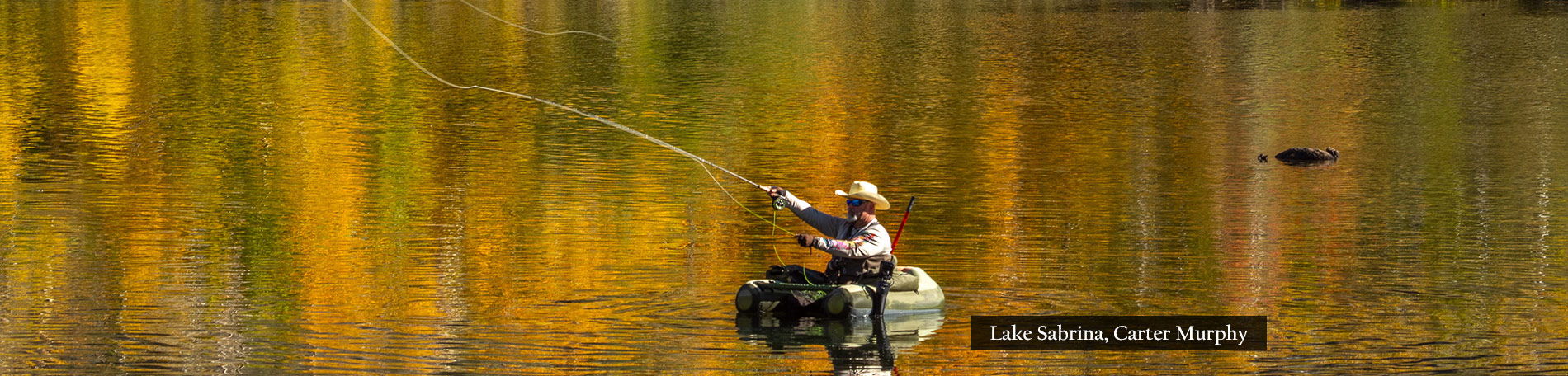
Lake Sabrina, M Fork Bishop Creek (10/1/19) Mike Schaper 
Groves Above Cardinal Village, M Fork Bishop Creek (10/1/19) Mike Schaper

Table Mountain, S Fork Bishop Creek (10/2/19) Mike Schaper 
Sabrina Camp, M Fork Bishop Creek (10/1/19) Mike Schaper 
Bracken fern, Lake Sabrina, M Fork Bishop Creek (10/1/19) Mike Schaper 
M Fork Bishop Creek (10/1/19) Mike Schaper 
M Fork Bishop Creek (10/1/19) Mike Schaper 
Sabrina Approach, M Fork Bishop Creek (10/1/19) Mike Schaper
Yet, Mick Schaper’s shots from Bishop Creek show vibrant color beside lots of green yet to turn. He writes, “Trees are lush with all phases of color change. No wind, so very few fallen leaves and no bare trees.”
He urges going now and estimates that next week, “some small areas will be past peak, but in general, the color should be more widespread and peak conditions will be even better than now.”
I guess this autumn’s beauty is in the eye of the beholder. Some see color, others see brown leaves.
Though I do worry that – because change in the Eastern Sierra is so late – once the green trees give up making chlorophyl, it will happen rapidly and if you’re not there exactly when it shifts, you’ll miss peak color at that location. So, no matter what, GO NOW!
Special Report: Yellowstone

Autumn arrived two weeks ago at Yellowstone National Park. Southern California color spotter Alena Nicholas was there to record its sparce beginnings.
Yellowstone’s fall color is limited to grasses and willows, as a cone-bearing forest (fir, pine juniper and spruce) covers 80% of the national park.
Nevertheless, in autumn, visual excitement is provided by the park’s abundant wildlife.
Rocky Mountain Elk were rutting and American Bison were grazing its plains. Alena even saw emaciated wolves in desperate search of sustenance.
At this point, the national park would be peaking, though fall color is limited to grasses, ground cover, shrubs and a few trees near the river.

Yellowstone River (9/20/19) Alena Nicholas 
Wetlands burst with fall color, Yellowstone NP (9/20/19) Alena Nicholas 
Small numbers of golden deciduous trees grow near the Yellowstone River (9/20/19) Alena Nicholas 
Elk, Yellowstone NP (9/20/19) Alena Nicholas 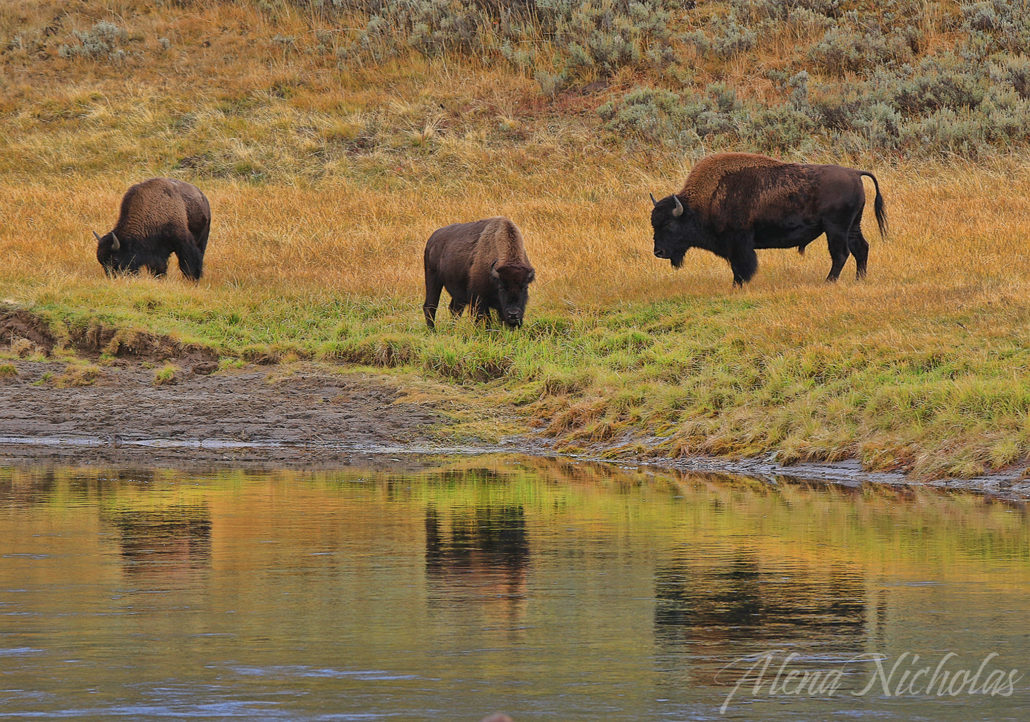
Bison, Yellowstone NP (9/20/19) Alena Nicholas 
Bison Yellowstone NP (9/20/19) Alena Nicholas 
Elk, Yellowstone NP (9/20/19) Alena Nicholas 
Elk, Yellowstone NP (9/20/19) Alena Nicholas 
Upper Yellowstone River Falls (9/20/19) Alena Nicholas 
Orange and gold fall color is provided by the grasses that grow across Yellowstone NP’s plains (9/20/19) Alena Nicholas
- Yellowstone National Park – Peak (75-100%) GO NOW!
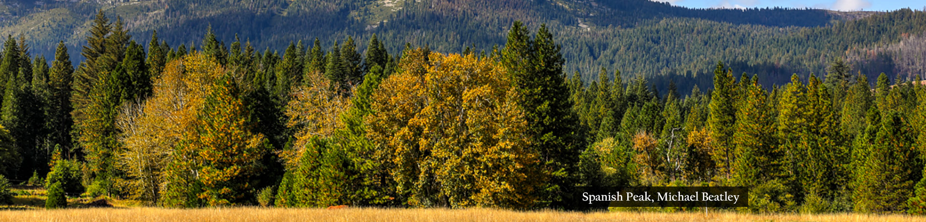
Silver Lake Is Looking Golden

Silver Lake near Meadow Valley looks nothing like its surrounding landscape. Plumas County is a forested place with bigleaf maple, mountain ash, aspen and lots of conifers.
Though Silver Lake, (see above) looks like it might better fit, tucked away in one of the granite canyons of the Eastern Sierra. That’s partly because the lake sits just below the Pacific Crest Trail, north of Spanish Peak. So, it is truly part of the High Sierra, even though classified as within the Shasta Cascade region.
Color spotter Michael Beatley scores a First Report for Silver Lake by sending the images he took this morning. He drove upon a USFS dirt road, that he describes as “well maintained” and “accessible by car,” six miles from Bucks Lake Rd. to Silver Lake.

USFS road to Silver Lake (10/3/19) Michael Beatley 
Mountain Ash, Silver Lake (10/3/19) Michael Beatley
Beatley says the deciduous trees and plants have yet to show much color, though the warm morning light reflecting off the conifers in the top photo made it appear that they are changing, though they aren’t.
- Silver Lake (7,200′) – Just Starting (0-10%)
Genessee, A Pleasant Valley

The Seneca word for a pleasant valley is Genessee, and California’s so-named place certainly is.
There, bigleaf maple, exotic elms and black oaks are changing more rapidly than in past years, reinforcing several observations of early fall color in the Northern Sierra.
Plumas County color spotter Jeff Luke Titcomb reports that the “maples are changing quickly. Greenville is about 20% at 3,400 feet but the change is going more quickly at lower elevations down to 2,200 feet.”
Driving through North Canyon to Round Valley Reservoir, he found bigleaf maple and creek dogwood at 30% change.

Elm, Genessee (10/2/19) Jeff Luke Titcomb 
Elm, Genessee (10/2/19) Jeff Luke Titcomb


Creek dogwood, Round Valley (10/1/19) Jeff Luke Titcomb 
Creek dogwood, Round Valley (10/1/19) Jeff Luke Titcomb
- Genessee (3,701′) – Patchy (10-50%)
- Greenville (3,586′) – Patchy (10-50%)
- Round Valley (5,692′) – Patchy (10-50%)
- Feather River Canyon (2,000 to 3,000′) – Patchy (10-50%)
YOU MISSED IT!

It was shocking to read “YOU MISSED IT!” in Jeff Simpson’s report from Mono County (Eastern Sierra), today.
He’d just visited Virginia Lakes, expecting peak color, but instead found that wind and cold had wiped out aspen groves near 9,819′.
That’s always a possibility, though it was an unexpected one.

Peak color still abounds near the Virginia Lakes at lower elevations, and elsewhere in Mono County similar elevations remain good.
Though, there is not the expected consistency this year that we saw in past years. Fall color conditions throughout Mono County vary wildly, depending on location and elevation. Only at the Virginia Lakes have you missed it entirely.

Rock Creek Lake (9/30/19) Dakota Snider 
Rock Creek Rd. (9/30/19) Dakota Snider
“Traditional fall favorites like Conway Summit, Lundy Canyon and Rock Creek are still trying to get going with mostly green and light green leaves,” though they should be popping next week.

Yet, beautiful peak color can still be seen at Rock Creek Lake, McGee Creek Canyon, Sagehen Summit, Upper Summers Meadow, Lobdell Lake and in the Sweetwater Mountains.
As always, when we advise to “GO NOW!”, please go. We get often get responses to our entreaty, pleading, “but I’d planned to visit next week,” or “will it still be peaking the first week of November?”
Yes it will, but not at the place we’re reporting is peaking now.
Fall color is perishable. It has a two week appearance from Near Peak to Peak … at most. Sometimes it will be near peak and a day or two later, full peak, then drop. And, by the time we get a photograph (whether provided to us or we take it) and post it, a day or two has passed.
So, please. When “GO NOW!” is posted, we mean it. GO NOW! or YOU MISSED IT!

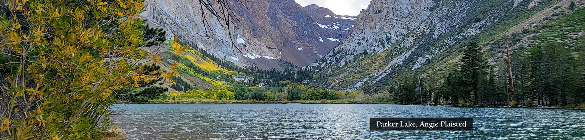
Hikes of the Week: Molybdenite Canyon, McGee Creek, Parker Lake and Lundy Canyon.

Sagehen Summit (10/1/19) Donna Mercer 
Sagehen Summit (10/1/19) Donna Mercer 
Sagehen Summit (10/1/19) Jeff Simpson/Mono County Tourism 
Sagehen Summit (10/1/19) Jeff Simpson/Mono County Tourism 
Sagehen Summit (10/1/19) Jeff Simpson/Mono County Tourism 
Sonora Pass (10/1/19) Jeff Simpson/Mono County Tourism 
Leavitt Meadow (10/1/19) Jeff Simpson/Mono County Tourism 
Parker Lake (10/1/19) Jeff Simpson/Mono County Tourism 
McGee Canyon (10/1/19) Jeff Simpson/Mono County Tourism 
McGee Canyon (10/1/19) Jeff Simpson/Mono County Tourism
Here’s Mono County from south to north along US 395 (reverse, if you’re heading south).
- Rock Creek Lake (9,600’) – Peak (75-100%) GO NOW! – Aspen are peaking at lake level.
- Rock Creek Road (below 9,600’) – Just starting to Patchy (0-50%)
- Crowley Community (6,781’) – Just Starting (0-10%)
- McGee Creek Canyon (8,600’) – Near Peak (50-75%) GO NOW! – A tribute to the Oakland A’s with lots of yellow and green. Super hike.
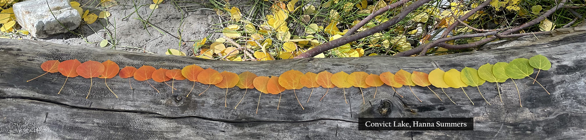
- Convict Lake (7850′) – Patchy (10-50%) – Color is developing slowly at the far end of the lake. Nice hike.
- Mammoth Lakes Basin (8,996′) – Patchy (10-50%)
- Devil’s Postpile National Monument (7,556’) – Patchy (10-50%)
- June Lake Loop/Hwy 158 (7,654′) – Just Starting (0-10%) – Plan on Oct. 15 for peak. Coming up a new event: Leaves In The Loop.
- Sagehen Summit (8,139’) – Peak (75-100%) GO NOW! – This is last call for Sagehen. Some groves are still orange, while others are near Past Peak. Should be over by next week.
- Tioga Pass (9,943′)– Patchy (10-50%) – Green, except along the road to Saddlebag Lake.
- Lee Vining Canyon (6,781′) – Just Starting (0-10%) Green.
- Lundy Lake & Canyon (7,858′) – Patchy (10-50%) – Colorful at the Beaver Ponds, but green around the lake. Still a week from peak along the road.
- Virginia Lakes (9,819’) – Past Peak YOU MISSED IT!–
- Conway Summit (8,143’) – Patchy (10-50%) – Mostly green.
- Twin Lakes (7,000’) – Just Starting (0-10%) – Small changes are noticeable. Should be good about Oct. 15.
- Molybdenite Creek Trail (7,865’) – Patchy (10-50%)
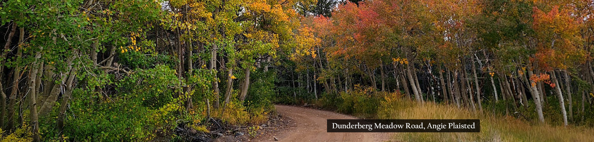
- Dunderberg Meadows (7,200’) – Just Starting (0-10%)
- Summers Meadow (7,146’) – Just Starting (0-10%) – It’s showing at high elevations, but hasn’t run downhill, yet.
- Upper Summers Meadow (10,300’) – Peak (75-100%) GO NOW!
- Lobdell Lake Road (8,600′) – Near Peak (50-75%) GO NOW! – Lovely mix of green, red, yellow and orange, though will peak slowly.
- Sonora Pass (9,623′) – Patchy (10-50%) – Turning nicely near the Levitt Meadows Pack Station.
- Walker Canyon, Walker, Coleville and Topaz (5,200′) – Patchy (10-50%) – This is a surprising start for the Antelope Valley with nice color along the West Walker River, and still green to turn ahead. Some trees have lost all leaves (early). Though Rodriquez Flat, Little Walker River Rd and Mill Canyon will be Near Peak this weekend
- Sweetwater Mountains (5,000 to 11,654’) – Near Peak (50-75%) GO NOW! – The East Walker River is doing the same on the east side of the Sweetwaters … showing early color though intensively.
- Monitor Pass (8,314′) – Just Starting (0-10%) – Still very green on top. Waiting patiently, but patience wears thin.
- Topaz (5,033’) – Just Starting (0-10%)


Bishop’s Back

We’re back with more photos of Bishop Creek Canyon. Color spotter Julie Kirby sent them, showing more of the peak color that is now dominating the canyon.

Julie’s photos were taken on Saturday, so a lot of the green and lime seen in them has now turned to yellow with all areas above 9,000′ at Peak.
Bishop Creek Canyon is peaking. This Eastern Sierra canyon, west of Bishop (US 395) in Inyo County, is often the first location in California to peak, and many believe that it is one of the most beautiful fall color destinations in North America.
What makes it so exceptional is that Bishop Creek is fed by three forks: south, middle and north. Paved roads travel beside each fork up separate canyons, ending at pristine lakes at 9,000’ in elevation. Beyond the lakes, Sierra peaks rise thousands of feet more to sawtooth peaks.
Often, snow covers these High Sierra peaks. Snow and the fall color (mostly aspen) reflect white, indigo, grey, red, orange, yellow and lime colors in the cobalt and turquoise waters of the lakes.
On evenings when cumulus clouds litter the sky, the setting sun illuminates the clouds with brilliant pink, purple, orange, red, blue, yellow and purple colors, that are reflected in the lakes.
It is this contrast of fall color, clear skies and the rugged majesty of the Sierra Nevada that exemplifies California Fall Color. This weekend and the following week such scenes will be common up Bishop Creek Canyon. It is a must-do experience that every Californian should witness, but it only happens for two weeks a year and that’s happening now.

Table Mountain, S Fork Bishop Creek (9/29/19) Julie Kirby 
Surveyor’s Meadow, S Fork Bishop Creek (9/29/19) Julie Kirby 
Surveyor’s Meadow, S Fork Bishop Creek (9/29/19) Julie Kirby 
Lake Sabrina, M Fork Bishop Creek (9/29/19) Julie Kirby 
Sabrina Approach, M Fork Bishop Creek (9/29/19) Julie Kirby 
North Lake Rd., N Fork Bishop Creek (9/29/19) Julie Kirby 
North Lake Rd., N Fork Bishop Creek (9/29/19) Julie Kirby 
North Lake Rd., N Fork Bishop Creek (9/29/19) Julie Kirby 
North Lake, N Fork Bishop Creek (9/29/19) Julie Kirby
Similarly, elevations above 9,000’ in Mono County (north of Inyo County) are now peaking. California’s first peak was reported there at Sagehen Summit and the Virginia Lakes (near Mono Lake).
Fall color was late to appear in the Eastern Sierra. That has been the general trend across the United States. Abnormal weather and precipitation have been blamed or credited for late or early appearances of fall color, according to a review of articles posted online.
In California, the Eastern Sierra is late by a week, the Northern Sierra (north of Lake Tahoe) and Southern Cascades are showing slightly early. All other areas of the state have not reported, significantly, which could mean they’re late or on time – it’s just too early to tell.

Etna Erupts

Holy smoke! Lori Quillen blew us away with this image of the Mormon Church in Etna surrounded by Near Peak exotic color and a meadow of native rabbitbrush.
Etna is in Scott Valley, at the foot of the Marble Mountain Wilderness (Siskiyou County) on CA-3. The town has but 737 souls living in it.
It’s lightly populated due to its remoteness, not its notoriety. After all, Etna was named after Italy’s famous stratovolcano Mt. Etna (10,991′) which happens to be 6,350 miles distant. Of course, Mt. Shasta (14,180′), the largest stratovolcano by volume in the Cascade volcanic arc, is a bit closer … 32 miles to the east as a crow flies, 62 by road.
The Scott Valley is a traditional center of cattle ranching, though also one now famous for outdoor recreation, serving visitors attracted to hike, fish, ride, bike, climb, ski, raft, kayak, camp and explore Siskiyou County’s great outdoors.

Route 3 is a popular fall color loop that begins in Redding (CA-299), continues to Weaverville, turns north to Trinity Center (CA-3), travels through the Trinity Alps, then loops back to Redding while passing through Etna, Greenview, Fort Jones, Yreka, Weed, Mt. Shasta City, Dunsmuir, and Shasta Lake.
The best fall color along this route is found along the Trinity and Scott rivers and their many tributaries including Coffee Creek.

Scott River Valley (9/30/19) Lori Quillen 
Scott River Valley (9/30/19) Lori Quillen 
Scott River Valley (9/30/19) Lori Quillen

A worthy detour is to head north from 299 to Lewiston where a silver, steel-truss bridge crosses the Trinity River and is surrounded by oak and maple, then either reverse course to 299 to include Weaverville or continue to CA-3 via Rush Creek Rd.
Although the color in Etna is now Near Peak, that’s only because non-native trees are peaking on their schedule. The rest of the loop is at the low end of Patchy, because the native trees peak later. The loop should be peaking the week of Oct. 20.
- Etna (2,936′) – Near Peak (50-75%) GO NOW!
- CA-3 Loop – Patchy (10-50%)